World Travel Tour Guide Tourism Trip Tip Packages Guide Map Hotels Resorts Accommodation SpasWorld Travel Tour Guide Tourism Trip Tip Packages Guide Map Hotels Resorts Accommodation SpasWorld Travel Tour Guide Tourism Trip Tip Packages Guide Map Hotels Resorts Accommodation SpasWorld Travel Tour Guide Tourism Trip Tip Packages Guide Map Hotels Resorts Accommodation SpasWorld Travel Tour Guide Tourism Trip Tip Packages Guide Map Hotels Resorts Accommodation Spas
Showing posts with label travel packages. Show all posts

Tuesday, August 2, 2011

มหาวิหารอาร์เทมีส ตุรกี Artemis

มหาวิหารอาร์เทมีส ตุรกี Artemis
เป็นวิหารสร้างด้วยหินอ่อน เลียบแบบศิลปะแบบกรีก เพื่อถวายเทพเจ้าอาร์เทมีส (เทพเจ้าแห่งดวงจันทร์ของกรีก) ผู้มาจากสวรรค์ ผู้ช่วยชาวเมืองให้พ้นจากหายนะและภัยพิบัติได้ อยู่ในเมืองอีเฟซุสบนชายฝั่งแห่งหนึ่งปัจจุบันนี้ คือประเทศตุรกี ในรัชสมัยของกษัตริย์อเล็กซานเดอร์แห่งกรีก จัดเป็นวัดที่สวยงามแห่งหนึ่งจนกลายเป็นที่รู้จักว่า เป็นสิ่งมหัศจรรย์ของโลกในยุคเก่า


http://www.wonder7th.com/1artemis.htm
http://www.oknation.net/blog/home/blog_data/620/2620/images/artemis06.jpg
http://www.oknation.net/blog/AoFkHaB/2007/03/23/entry-8

วิหารนี้มีเนื้อที่ถึง 54,720 ตารางฟุต ตัวอาคารมีความกว้างถึง 400 ฟุต บริเวณโดยรอบวัดแห่งนี้กิน เนื้อที่เกือบ 2 เอเคอร์ และมีเสาหินตั้งตระหง่านรอบตัวอาคารมากกว่า 100 เสาหิน แต่ละเสาหินมีเส้นผ่านศุนย์กลาง 6 ฟุต ความสูง 60 ฟุต หลังคาปูด้วยกระเบื้องหินอ่อน ภายในโบสถ์เป็นที่ประดิษฐานเทพเจ้าชื่อว่า อาร์ทิมีส หรืออีกชื่อหนึ่ง ว่าไดอาน่า ประชาชนจะนำสิ่งของมาสักการะบูชา ส่วนมากเป็นสิ่งของมีค่ามากมาย

เคยถูกไฟไหม้เสียหายครึ่งหนึ่งแต่ได้รับการซ่อมแซมใหม่โดยกษัตริย์อเล็กซานเดอร์ วิหารแห่งนี้ได้ถูก ทำลายสิ้นก่อนปี ค.ศ. 262 จึงเหลือแต่ซากปรักหักพังเก็บไว้ชมอยู่ในกรุงอิสตันบลู ประเทศตุรกี

Saturday, July 2, 2011

มาชู ปิกชู อาณาจักรอินคา เปรู


มาชูปิกชู (เกชัว: Machu Picchu) หรือนิยมเรียกอีกชื่อว่า เมืองสาบสูญแห่งอินคา เป็นซากอารยธรรมโบราณของชาวอินคา ตั้งอยู่บนเทือกเขาสูงในประเทศเปรู ที่ความสูงประมาณ 2,350 เมตร อารยธรรมแห่งนี้ได้ถูกลืมโดยคนภายนอกจนกระทั่งมีการค้นพบอีกครั้งโดยนักโบราณคดีที่ชื่อ ไฮแรม บิงแฮม เมื่อ พ.ศ. 2454 มาชูปิกชูเป็นหลักฐานที่สำคัญของจักรวรรดิอินคา ในปี พ.ศ. 2526 องค์กรยูเนสโกได้กำหนดมาชูปิกชูให้เป็นมรดกโลก โดยทำให้เป็นสถานที่ท่องเที่ยวที่คนนิยมไปศึกษาประวัติศาสตร์

7 กรกฎาคม พ.ศ. 2550 มาชูปิกชูได้รับเลือกให้เป็นหนึ่งในเจ็ดสิ่งมหัศจรรย์ของโลกยุคใหม่ จากการลงคะแนนทั่วโลกทั้งทางอินเทอร์เน็ตและโทรศัพท์มือถือ

ประวัติ

มาชูปิกชูสร้างขึ้นประมาณปี พ.ศ. 1993 โดยจักรพรรดิปาชากูตีของอินคา และใช้ชีวิตในมาชูปิกชูจนกระทั่งชาวสเปนได้ชัยชนะเหนือเปรูใน พ.ศ. 2454 = ค.ศ.1911 ใช่หรือ เมื่อไม่นานมานี้นักพิสูจน์หลักฐานทางโบราณคดีแสดงหลักฐานว่า มาชูปิกชูไม่ได้เป็นกลุ่มหรือเมือง แต่เป็นการสร้างที่พักอาศัยของผู้ดีชาวอินคา (คล้าย ๆ กับบ้านพักตากอากาศของเศรษฐีชาวยุโรป) พื้นที่โดยส่วนใหญ่เป็นปราสาทและวัดที่สร้างเพื่อถวายแค่เทพพระเจ้าของชาว อินคา และสิ่งปลูกสร้างอื่น ๆ ที่สร้างเพื่อผู้ดูแลศาสนสถาน

มีการตั้งสมมุติฐานว่าในมาชูปิกชูมีจำนวนประชากรอาศัยอยู่สูงสุดประมาณ 750 คน ณ ช่วงเวลาหนึ่ง บางส่วนจะอาศัยอยู่ในเมืองระหว่างฤดูฝน และจะกลับมาที่มาชูปิกชู เป็นชั่วครั้งชั่วคราวเท่านั้น

ในปี พ.ศ. 2456 หลังจากที่ National Geographic Society ศึกษาข้อมูลเกี่ยวกับมาชูปิกชูทั้งหมด ในช่วงเดือนเมษายน ก็ได้ทำการเผยแพร่ออกไป

http://th.wikipedia.org/wiki/มาชู_ปิกชู
http://mail.vcharkarn.com/varticle/38566

Sunday, June 19, 2011

วิหารพาร์เธนอน เอเธนส์ กรีซ

วิหารพาร์เธนอน เอเธนส์ กรีซ
วิหารพาร์เธนอน (ภาษากรีก:το parthenon) คือวิหารโบราณบนเนินอะโครโพลิสในกรุงเอเธนส์ ประเทศกรีซ สร้างเพื่อเป็นศาสนสถานบูชาเทพีเอเธนา หรือเทพีแห่งปัญญา ความรอบรู้ ในศตวรรษที่ 5 ก่อนคริสต์ศักราช เป็นสิ่งก่อสร้างสถาปัตยกรรมกรีกโบราณที่มีชื่อเสียงที่สุด แสดงให้เห็นถึงความเฉลียวฉลาดของสถาปนิกในสมัยนั้นและถือได้ว่าเป็นหนึ่งในสิ่งก่อสร้างที่ยิ่งใหญ่ที่สุดในโลก มีขนาดกว้าง 101.4 ฟุต หรือ 30.9 เมตร และ ยาว 228.0 ฟุต หรือ 69.5 เมตร

คำว่า พาร์เธนอน นั้นน่าจะมาจากประติมากรรมที่เคยตั้งอยู่ภายในวิหาร คือ Athena Parthenos ซึ่งมีความหมายว่า เทพีอันบริสุทธิ์


http://th.wikipedia.org/wiki/วิหารพาร์เธนอน
http://www.thaigoodview.com/files/u4925/9.jpg
http://www.thaigoodview.com/node/19628

Thursday, June 2, 2011

สวนลอยแห่งกรุงบาบิโลน อิรัก

สวนลอยแห่งกรุงบาบิโลน อิรัก
สวนลอยบาบิโลน (อังกฤษ: Hanging Gardens of Babylon) จัดเป็นหนึ่งในเจ็ดสิ่งมหัศจรรย์ของโลก ตั้งอยู่บนแม่น้ำยูเฟรติส ประเทศอิรักในปัจจุบัน สร้างโดยกษัตริย์เนบูคัดเนสซาร์ที่ 3 แห่งกรุงบาบิโลเนีย สร้างให้แก่มเหสีของพระองค์ชื่อพระนางเซมีรามีส สร้างขึ้นเมื่อ 600 ปีก่อนคริสต์ศักราช สุงประมาณ 75 ฟุต กินพื้นที่ 400 ตารางฟุต ระเบียงทุกชั้นได้รับการตกแต่งด้วยไม้ดอก ไม้ประดับ ไม้ยืนพุ่มชนิดต่างๆ มีระบบชลประทานชักน้ำจากแม่น้ำไทกิสไปทำเป็นน้ำตกและนำไปเลี้ยงต้นไม้ตลอดปี ปัจจุบันสวนนี้ได้พังทลายไปหมดแล้ว

http://th.wikipedia.org/wiki/สวนลอยบาบิโลน

สวนลอยแห่งกรุงบาบิโลน : The Hanging Gardens of Babylon
สวนลอยแห่งกรุงบาบิโลน : The Hanging Gardens of Babylon ... คือ พระเจ้าเนบูชัดเนซซาร์ที่สอง ปกครองบาบิโลนซึ่งได้ขยายแสนยานุภาพออกไปมากมายจนรุ่งเรือง ...
www.wonder7th.com/1babylon.htm

สวนลอยแห่งกรุงบาบิโลน
สวนลอยแห่งกรุงบาบิโลน. The Hanging Gardens of Babylon. สวนลอยแห่งกรุงบาบิโลน. ตำแหน่งที่ตั้ง. กลางทะเลทราย เมืองแบกแดด ริมฝั่งแม่น้ำยูเฟรติส ประเทศอิรัก ...
members.tripod.com/com_sk/babylon.htm

สิ่งมหัศจรรย์ของโลก
สวนลอยแห่งกรุงบาบิโลน (ยุคโบราณ). สวนลอยบาบิโลน (Babylonian) มีอายุประมาณ 4000 ปี ตั้งอยู่ริมฝั่งแม่น้ำยูเฟรติส ประเทศอิรักในปัจจุบัน สร้างขึ้นโดย ...
www.baanjomyut.com/library/wonderful/babylon.html

สวนลอยแห่งกรุงบาบิโลน
ส่วนเราว่าสิ่งที่อ่านแล้วน่าสนใจมากที่สุดก็คือ “สวนลอยแห่งกรุงบาบิโลน” หรือภาษาอังกฤษว่า “The Hanging Gardens of Babylon” มันฟังดูลึกลับและน่าสนใจในดี ...
manaplovely.blogspot.com/2007/07/blog-post_19.html

สวนลอยแห่งกรุงบาบิโลน
สวนลอยแห่งกรุงบาบิโลน ... เพราะสวนลอยแห่งนี้สร้างขึ้นเหนือพื้นดินบนพื้นที่กึ่ง ... ทรายแห่งนี้จะเห็นสวนลอยอันงดงามแต่ไกลเมื่อเข้าสู่เขตตัวเมือง ...
talung.pt.ac.th/ptweb/studentweb/amazing/d3.html

http://mblog.manager.co.th/peacock/Rivers-of-Babylon/

Tuesday, May 24, 2011

นครต้องห้าม พระราชวังต้องห้าม จีน

พระราชวังต้องห้าม - วิกิพีเดีย
พระราชวัง ต้องห้าม (จีน: 紫禁城; พินอิน: Zǐjìn Chéng จื่อจิ้นเฉิง; ... โดยมีสนมกำนัล ขันที และข้าหลวงรับใช้ ซึ่งคนเหล่านี้ต้องอาศัยอยู่ในนครต้องห้ามตลอดชีวิต ... ชื่อ - ประวัติ - โครงสร้างและสถาปัตยกรรม - อ้างอิง
th.wikipedia.org/wiki/พระราชวังต้องห้าม

กู้กง - นครต้องห้าม เมืองปักกิ่ง
กู้กง เป็นชื่อของอดีตพระราชวังหลวงของปักกิ่ง เรียกเป็นภาษาอังกฤษว่า The Forbidden City หรือนครต้องห้าม เพราะถึงแม้ว่าเป็นวัง ...
www.wlc2china.com/The_Forbidden_City.html

นครต้องห้าม : Forbidden city มหัศจรรย์สิ่งก่อสร้าง
ถัด จากกำแพงยักษ์ของเมืองจีนไปทางใต้ประมาณ 80 กิโลเมตร (50 ไมล์) เป็นที่ตั้งของนครต้องห้ามที่สร้างขึ้นด้วยพระบรมราชโองการของกุบไลข่านจอม จักรพรรดิ ...
www.wonder7th.com › Wonder Build

http://upload.wikimedia.org/wikipedia/commons/thumb/6/68/Forbidden_city_07.jpg/290px-Forbidden_city_07.jpg
http://th.wikipedia.org/wiki/พระราชวังต้องห้าม

นครต้องห้าม พระราชวังต้องห้าม จีน

พระราชวังต้องห้าม (จีน: 紫禁城; พินอิน: Zǐjìn Chéng จื่อจิ้นเฉิง; อังกฤษ: Forbidden City) จากชื่อภาษาจีน แปลตามตัวอักษรได้ว่า "เมืองต้องห้ามสีม่วง" พระราชวังต้องห้ามตั้งอยู่ใจกลางของกรุงปักกิ่ง เมืองหลวงของประเทศจีน ( 39°54′56″N, 116°23′27″E) เป็นพระราชวังหลวงมาตั้งแต่สมัยกลางราชวงศ์หมิงจนถึงราชวงศ์ชิง พระราชวังต้องห้ามยังรู้จักกันในนาม พิพิธภัณฑ์พระราชวัง (ภาษาจีน: 故宫博物院; พินอิน: Gùgōng Bówùyùan) ครอบคลุมพื้นที่ 720,000 ตารางเมตร อาคาร 800 หลัง มีห้องทั้งหมด 9,999 ห้อง[1] และมีพระที่นั่ง 75 องค์ หอพระสมุด ห้องหับต่างๆอีกมาก รวมทั้งยังมีสวน ลานกว้าง ทางเดินเชื่อมกันโดยตลอด มีคูและกำแพงที่สูงถึง 11 เมตร[2] ล้อมรอบ ใช้ระยะก่อสร้างประมาณ 14 ปี ตั้งแต่ พ.ศ. 1949 จนถึง พ.ศ. 1963

พระราชวังต้องห้ามตั้งอยู่ทางทิศเหนือของจตุรัสเทียนอันเหมิน นักท่องเที่ยวสามารถเข้าสู่พระราชวังต้องห้ามได้ทางจตุรัสนี้ ผ่านประตูเทียนอันเหมิน บริเวณรอบจตุรัสเทียนอันเหมิน เรียกว่า อาณาเขตหลวง โดยมีสิ่งก่อสร้างสำคัญอยู่โดยรอบ เช่น มหาศาลาประชาคม ในอดีต พระราชวังแห่งนี้ เป็นเขตหวงห้ามไม่ไห้ประชาชนเข้า แม้ข้าราชการชั้นสูง ยังต้องขออนุญาต เป็นกรณีพิเศษ จึงเรียกพระราชวังนี้ว่า "พระราชวังต้องห้าม" จักรพรรดิจะทรงประทับอยู่ในพระราชวังแห่งนี้ กั้นพระองค์จากโลกภายนอก โดยมีสนมกำนัล ขันที และข้าหลวงรับใช้ ซึ่งคนเหล่านี้ต้องอาศัยอยู่ในนครต้องห้ามตลอดชีวิต เพื่อความสำราญของจักรพรรดิ ในวังจะมีวิเสท 6,000 คน ประกอบพระกระยาหาร มีสนมกำนัล 9,000 นาง ซึ่งมีขันที 70,000 คน คอยดูแลให้ มีคำเล่าลือกันว่า พระนางซูสีไทเฮา เวลาเสวยก็จะมีพระกระยาหารถึง 148 ชุด และทรงส่งขันทีไปเสาะหาชายหนุ่มซึ่งเข้าวังแล้วจะไม่มีผู้ใดพบเห็นอีกเลย

แม้ว่าประเทศจีนจะไม่มีสถาบันพระมหากษัตริย์แล้ว พระราชวังต้องห้ามก็ยังคงเป็นสัญลักษณ์ของประเทศจีน และภาพประตูเทียนอันเหมินก็ยังปรากฏอยู่ในตราประจำสาธารณรัฐประชาชนจีนอีก ด้วย นอกจากนี้ พระราชวังต้องห้ามยังเป็นสถานที่ท่องเที่ยวที่มีชื่อเสียงที่สุดแห่งหนึ่ง ของโลก ซึ่งไม่นานมานี้ ทางรัฐบาลจีนได้มีนโยบายจำกัดปริมาณนักท่องเที่ยวเพื่อจะอนุรักษ์สภาพของ อาคารและสวนหย่อมไว้

ยูเนสโกได้ประกาศให้พระราชวังต้องห้ามร่วมกับพระราชวังเสิ่นหยางเป็นหนึ่งในมรดกโลกในนาม พระราชวังหลวงแห่งราชวงศ์หมิงและราชวงศ์ชิงในปักกิ่งและเสิ่นหยาง เมื่อ พ.ศ. 2530 (ค.ศ. 1987)

ชื่อ

พระราชวังต้องห้ามเป็นที่รู้จักในหลากหลายชื่อ ในภาษาจีนนั้น ชาวจีนจะเรียกพระราชวังต้องห้ามว่า กู้กง (จีน: 故宫; พินอิน: Gùgōng) ซึ่งแปลว่า พระราชวังเก่า นอกจากนี้ คำนี้ยังใช้เรียกพระราชวังเก่าตามเมืองต่างๆ ที่มีอยู่ทั่วไปในประเทศจีนด้วย

ส่วนคำที่เรารู้จักกันดีว่า "พระราชวังต้องห้าม" นั้น แปลมาจากภาษาจีน จื่อจิ้น เฉิง (จีน: 紫禁城; พินอิน: Zǐjìn Chéng) ซึ่งแปลตามตัวอักษรได้ว่า "เมืองต้องห้ามสีเลือดหมู" ด้วยเหตุที่ว่า ห้ามสามัญชนเข้าไปในบริเวณวังหลวงโดยเด็ดขาด และสีเลือดหมูนั้นเป็นสีอาคารและหลังคาโดยทั่วไป

ประวัติ

สถานที่ที่ตั้งของพระราชวังโบราณนี้แต่เดิมนั้นก็คือพระราชวังหลวงของราชวงศ์หยวนแห่งมองโกล ซึ่งต่อมาเมื่อราชวงศ์หยวนล่มสลายลงแล้วมีราชวงศ์หมิงขึ้นมาแทน จักรพรรดิพระองค์แรกของราชวงศ์หมิง จักรพรรดิหงอู่ได้ย้ายเมืองหลวงจากปักกิ่งไปนานกิงและดำริให้รื้อถอนพระราชวังออก ซึ่งต่อมาเมื่อพระราชโอรสของพระองค์ จักรพรรดิหย่งเล่อได้ขึ้นครองราชย์ พระองค์ก็ได้ย้ายเมืองหลวงกลับปักกิ่งดั่งเดิม และทรงสั่งให้ก่อสร้างพระราชวังใหม่ขึ้นในปี พ.ศ. 1949 ซึ่งต่อมาได้กลายมาเป็นพระราชวังต้องห้ามแห่งนี้

ต่อมาในปี พ.ศ. 2187 ได้เกิดจลาจลขึ้นทำให้พระราชวังสมัยราชวงศ์หมิงเสียหายไป และเมื่อราชวงศ์ชิงขึ้นครองอำนาจต่อจากราชวงศ์หมิง ทางราชวงศ์ชิงก็ ได้ก่อสร้างสร้างขึ้นมาใหม่บนฐานสิ่งก่อสร้างเดิม ทำให้พระราชวังกลายมาเป็นจุดศูนย์กลางอำนาจของจีนอีกครั้งหนึ่งเรื่อยมาจน ถึงการล่มสลายของราชวงศ์ชิง และการเปลี่ยนมาเป็นระบอบสาธารณรัฐ

http://th.wikipedia.org/wiki/พระราชวังต้องห้าม

แผนที่ :


นครต้องห้าม
นครต้องห้าม. ตั้งอยู่ที่ประเทศจีนกลางกรุงปักกิ่ง โดยจักรพรรดิกุบไลข่านเป็นผู้สร้างเพื่อใช้ว่าราชการ ...
www.thaigoodview.com/library/studentshow/.../asia2.html

นครต้องห้าม (Forbidden city) - PaLungJit.com
นครต้องห้ามอย่างแท้จริงอยู่ด้านในเริ่มจากทางเข้าที่สำคัญอันที่รู้จักกันดีในนามที่เรียกว่า พระทวารสรวงสวรรค์สันติ ...
board.palungjit.com › ทั่วไป › จักรวาลคู่ขนาน

Sunday, May 15, 2011

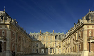
พระราชวังแวร์ซายส์ ปารีส ฝรั่งเศส

พระราชวังแวร์ซายส์ ปารีส ฝรั่งเศส

พระราชวังแวร์ซายส์ - วิกิพีเดีย
พระ ราชวังแวร์ซายส์ (ภาษาฝรั่งเศส: Château de Versailles) เป็นพระราชวังหลวงแห่งหนึ่งของประเทศฝรั่งเศส ตั้งอยู่ที่เมืองแวร์ซายส์ ...
th.wikipedia.org/wiki/พระราชวังแวร์ซายส์

พระราชวังแวร์ซายส์ (ภาษาฝรั่งเศส: Château de Versailles) เป็นพระราชวังหลวงแห่งหนึ่งของประเทศฝรั่งเศส ตั้งอยู่ที่เมืองแวร์ซายส์ ซึ่งปัจจุบันเป็นส่วนหนึ่งของมหานครปารีส พระราชวังแวร์ซายส์เป็นพระราชวังที่ยิ่งใหญ่และสวยงามแห่งหนึ่งของโลก และนับเป็นหนึ่งในเจ็ดสิ่งมหัศจรรย์ของโลกยุคปัจจุบันด้วย

ประวัติ

เดิมนั้น เมืองแวร์ซายส์เป็นเพียงเมืองเล็ก ๆ แห่งหนึ่งเท่านั้น มีผู้คนอาศัยอยู่เบาบาง บริเวณส่วนใหญ่เป็นป่าเขา เยี่ยงชนบทอื่น ๆ ของฝรั่งเศส เมื่อพระเจ้าหลุยส์ที่ 13 ยังทรงพระเยาว์ ขณะพระชนมายุได้ 23 พระชันษา ทรงนิยมล่าสัตว์ในป่า และทรงเห็นว่าตำบลแวร์ซายส์น่าจะเหมาะแก่การประทับเพื่อล่าสัตว์ จึงโปรดเกล้าฯ ให้สร้างพระตำหนักขึ้นมาใน พ.ศ. 2167 โดยในช่วงแรกเป็นเพียงกระท่อมเล็กๆ สำหรับพักชั่วคราวเท่านั้น

เมื่อ พระเจ้าหลุยส์ที่ 14 แห่งฝรั่งเศส ขึ้นครองบัลลังก์ มีประสงค์ที่จะสร้างพระราชวังแห่งใหม่ เพื่อเป็นศูนย์กลางในการปกครองของพระองค์ จึงเริ่มปรับปรุงพระตำหนักเดิมในปี พ.ศ. 2204 ใช้เงินทั้งหมด 500,000,000 ฟรังก์ คนงาน 30,000 คน และใช้เวลาอยู่ถึง 30 ปีจึงแล้วเสร็จในพ.ศ. 2231 ทุกส่วนทำด้วยหินอ่อนสีขาว เป็นแบบอย่างศิลปกรรมที่งดงามมาก ภาย ในแบ่งออกเป็นห้องๆ เช่น ห้องบรรทม ห้องเสวย ห้องสำราญ ฯลฯ ทุกห้องล้วนมีเครื่องประดับงดงามตระการตาและภาพเขียนที่มีชื่อเสียง

การก่อสร้างพระราชวังแวร์ซายส์แห่งนี้ได้นำเงินมาจากค่าภาษีอากรของราษฎร ชาวฝรั่งเศส ต่อมาจึงได้มีกองทัพประชาชนบุกเข้ายึดพระราชวังและจับพระเจ้าหลุยส์ที่ 16 กับพระนางมารี อองตัวเนต ประหารด้วย "กิโยติน" ในวันที่ 6 ตุลาคม พ.ศ. 2332 ปัจจุบันพระราชวังแวร์ซายส์ยังอยู่ในสภาพดีและเปิดให้ประชาชนเข้าชมได้

http://th.wikipedia.org/wiki/พระราชวังแวร์ซายส์
http://www.nanmeebooks.com/webboard/uploadWebboard/800px-Versailles_Palace%5B1%5D.jpg
http://www.nanmeebooks.com/webboard/topic.php?postid=00005345&wbr_id=18

Sunday, April 24, 2011

Forbidden City China

Forbidden City - Wikipedia, the free encyclopedia
The Forbidden City was the Chinese imperial palace from the Ming Dynasty to the end of the Qing Dynasty. It is located in the middle of Beijing, China, ... Name - History - Description - Collections
en.wikipedia.org/wiki/Forbidden_City

The Forbidden City : A Virtual Tour - Beijing Tour : China Virtual ...
The Forbidden City. A virtual tour of the grand imperial palace in Beijing. Presented by China Vista.
www.chinavista.com/beijing/gugong/!start.html

Forbidden City, Beijing Palace Museum, Gugong Tour Guide, China
Forbidden City facts and tour guide about imperial palace museum in Beijing, China with pictures, entrance fee, history, opening hour and videos.
www.travelchinaguide.com/cityguides/beijing/forbidden.htm

Forbidden City China
http://riawibisono.wordpress.com/2007/07/17/my-version-of-7-wonders-of-the-world/

Forbidden City China

The Forbidden City was the Chinese imperial palace from the Ming Dynasty to the end of the Qing Dynasty. It is located in the middle of Beijing, China, and now houses the Palace Museum. For almost five centuries, it served as the home of the Emperor and his household, as well as the ceremonial and political centre of Chinese government.

Built from 1406 to 1420, the complex consists of 980 surviving buildings with 8,707 bays of rooms and covers 720,000 m2 (7,800,000 sq ft). The palace complex exemplifies traditional Chinese palatial architecture, and has influenced cultural and architectural developments in East Asia and elsewhere. The Forbidden City was declared a World Heritage Site in 1987, and is listed by UNESCO as the largest collection of preserved ancient wooden structures in the world.

Since 1925, the Forbidden City has been under the charge of the Palace Museum, whose extensive collection of artwork and artifacts were built upon the imperial collections of the Ming and Qing dynasties. Part of the museum's former collection is now located in the National Palace Museum in Taipei. Both museums descend from the same institution, but were split after the Chinese Civil War.

Name

The Gate of Divine Might, the northern gate. The lower tablet reads "The Palace Museum" (故宫博物院)

The common English name, "the Forbidden City," is a translation of the Chinese name Zijin Cheng (Chinese: 紫禁城; pinyin: Zǐjinchéng; literally "Purple Forbidden City"). Another English name of similar origin is "Forbidden Palace".

The name "Zijin Cheng" is a name with significance on many levels. Zi, or "Purple", refers to the North Star, which in ancient China was called the Ziwei Star, and in traditional Chinese astrology was the abode of the Celestial Emperor. The surrounding celestial region, the Ziwei Enclosure (Chinese: 紫微垣; pinyin: Zǐwēiyuán), was the realm of the Celestial Emperor and his family. The Forbidden City, as the residence of the terrestrial emperor, was its earthly counterpart. Jin, or "Forbidden", referred to the fact that no-one could enter or leave the palace without the emperor's permission. Cheng means a walled city.

Today, the site is most commonly known in Chinese as Gùgōng (故宫), which means the "Former Palace." The museum which is based in these buildings is known as the "Palace Museum" (Chinese: 故宫博物院; pinyin: Gùgōng Bówùyùan).

History

Main article: History of the Forbidden City
The Forbidden City as depicted in a traditional Ming Dynasty painting

The site of the Forbidden City was situated on the Imperial City during the Mongol Yuan Dynasty. Upon the establishment of the Ming Dynasty, the Hongwu Emperor moved the capital from Beijing in the north to Nanjing in the south, and ordered that the Yuan palaces be burnt down. When his son Zhu Di became the Yongle Emperor, he moved the capital back to Beijing, and construction began in 1406 of what would become the Forbidden City.

Construction lasted 15 years, and required more than a million workers.Material used include whole logs of precious Phoebe zhennan wood (Chinese: 楠木; pinyin: nánmù) found in the jungles of south-western China, and large blocks of marble from quarries near Beijing.[7] The floors of major halls were paved with "golden bricks" (Chinese: 金砖; pinyin: jīnzhuān), specially baked paving bricks from Suzhou.

From 1420 to 1644, the Forbidden City was the seat of the Ming Dynasty. In April 1644, it was captured by rebel forces led by Li Zicheng, who proclaimed himself emperor of the Shun Dynasty.[8] He soon fled before the combined armies of former Ming general Wu Sangui and Manchu forces, setting fire to parts of the Forbidden City in the process.[9] By October, the Manchus had achieved supremacy in northern China, and a ceremony was held at the Forbidden City to proclaim the young Shunzhi Emperor as ruler of all China under the Qing Dynasty.[10] The Qing rulers changed the names of the principal buildings, to emphasise "Harmony" rather than "Supremacy",made the name plates bilingual (Chinese and Manchu),and introduced Shamanist elements to the palace.

In 1860, during the Second Opium War, Anglo-French forces took control of the Forbidden City and occupied it until the end of the war.In 1900 Empress Dowager Cixi fled from the Forbidden City during the Boxer Rebellion, leaving it to be occupied by forces of the treaty powers until the following year.

After being the home of 24 emperors—fourteen of the Ming Dynasty and ten of the Qing Dynasty—the Forbidden City ceased being the political centre of China in 1912 with the abdication of Puyi, the last Emperor of China. Under an agreement with the new Republic of China government, Puyi remained in the Inner Court, while the Outer Court was given over to public use, until he was evicted after a coup in 1924. The Palace Museum was then established in the Forbidden City.In 1933, the Japanese invasion of China forced the evacuation of the national treasures in the Forbidden City.Part of the collection was returned at the end of World War II, but the other part was evacuated to Taiwan in 1947 under orders by Chiang Kai-shek, whose Kuomintang was losing the Chinese Civil War. This relatively small but high quality collection was kept in storage until 1965, when it again became public, as the core of the National Palace Museum in Taipei.
The East Glorious Gate under renovation as part of the 19-year restoration process

After the establishment of the People's Republic of China in 1949, some damage was done to the Forbidden City as the country was swept up in revolutionary zeal. During the Cultural Revolution, however, further destruction was prevented when Premier Zhou Enlai sent an army battalion to guard the city.

The Forbidden City was declared a World Heritage Site in 1987 by UNESCO as the "Imperial Palace of the Ming and Qing Dynasties", due to its significant place in the development of Chinese architecture and culture. It is currently administered by the Palace Museum, which is currently carrying out a sixteen-year restoration project to repair and restore all buildings in the Forbidden City to their pre-1912 state.

In recent years, the presence of commercial enterprises in the Forbidden City has become controversial.A Starbucks store that opened in 2000 sparked objections and eventually closed on July 13, 2007. Chinese media also took notice of a pair of souvenir shops that refused to admit Chinese citizens in order to price-gouge foreign customers in 2006.

http://en.wikipedia.org/wiki/Forbidden_City

Saturday, April 2, 2011

ทัชมาฮาล อินเดีย

ทัชมาฮาล - วิกิพีเดีย
ทัชมาฮาล สุสานหินอ่อนที่ผู้คนเชื่อว่าเป็นสถาปัตยกรรมแห่งความรักที่สวยที่สุดในโลก ถูกสร้างขึ้นโดยกษัตริย์อินเดียผู้มีรักมั่นคงต่อพระมเหสีของพระองค์ ...
th.wikipedia.org/wiki/ทัชมาฮาล


ทัชมาฮัล : Taj Mahal
มุมทัชมาฮาล เป็นมเหสีที่พระเจ้าชาห์เยฮันรักมากที่สุด ... ปะการัง และ หอยมุกจากมหาสมุทรอินเดีย หินเจียรไนสีฟ้าจากเกาะลังขะ เพชรจากเมืองบนทลขัณฑ์ ...
www.wonder7th.com/3taj_mahal.htm


ทัชมาฮาล (ภาษาฮินดี : ताजमहल, ตาช มฮัล รากศัพท์เดิมมาจากภาษาอาหรับ ตาจญ์ (มงกุฎ) และ มะฮัล (สถาน) (ภาษาอาหรับ : تاج محل ) เป็นอนุสรณ์สถาน ตั้งอยู่ในเมืองอัครา ประเทศอินเดีย นับเป็นหนึ่งในเจ็ดสิ่งมหัศจรรย์ของโลกยุคใหม่

ประวัติ

ทัชมาฮาล สุสานหินอ่อนที่ผู้คนเชื่อว่าเป็นสถาปัตยกรรมแห่งความรักที่สวยที่สุดในโลก ถูกสร้างขึ้นโดยกษัตริย์อินเดียผู้มีรักมั่นคงต่อพระมเหสีของพระองค์ เจ้าชายขุร์รัม ชึ่งต่อมาคือจักรพรรดิชาห์ ชหาน พระราชสมภพในปี พ.ศ. 2135 (ค.ศ. 1592) พระบิดา คือ จักรพรรดิ ชาห์ ชหานชีร์ จักรพรรดิองค์ที่สี่แห่งราชวงศ์โมกุล แห่งอินเดีย ตามตำนานกล่าวว่า เจ้าชายขุร์รัม ได้พบกับ อรชุมันท์ พานุ เพคุม ธิดาของรัฐมนตรี เมื่อพระองค์ มีพระชนมายุ 14 พรรษา พระองค์ทรงหลงใหลและหลงรักนาง เจ้าชายขุร์รัมจึงซื้อเพชรด้วยเงิน 10,000 รูปีและบอกแก่พระบิดาของพระองค์ว่าพระองค์มีความประสงค์ที่จะแต่งงานกับบุตร สาวของรัฐมนตรี พิธีอภิเษกถูกจัดขึ้นหลังจากนั้น 5 ปี ในปี พ.ศ. 2155 (ค.ศ. 1612) จากนั้นมาทั้งสองก็มิเคยอยู่ห่างกันอีกเลย

หลังจากที่พระเจ้าชาห์ ชหาน ขึ้นครองราชบัลลังก์ในปี พ.ศ. 2171 พระองค์มอบความไว้วางใจแก่ อรชุมันท์ พานุ เพคุม และเรียกนางว่า มุมตัซ มาฮาล "อัญมณีแห่งราชวัง" พระมเหสีติดตามพระองค์ แม้แต่ในสนามรบ แนะนำพระองค์ในเรื่องราชการของประเทศ และพระองค์ซาบซึ้งในน้ำพระทัยของพระมเหสียิ่งนัก ครั้นในปี พ.ศ. 2174 (ค.ศ. 1631) พระมเหสีมุมตัซสิ้นพระชนม์ หลังจากให้กำเนิดทายาทองค์ที่ 14 การสิ้นพระชนม์ของพระมเหสีทำให้พระเจ้าชาห์ ชหานโศกเศร้าอยู่ถึงสองทศวรรษ ราชสมบัติส่วนใหญ่สูญเสียไปเพื่อการสร้างอนุสรณ์แห่งความรักของทั้งสองพระองค์

ในปี พ.ศ. 2200 (ค.ศ. 1657) พระเจ้าชาห์ ชหานทรงพระประชวร และในปี พ.ศ. 2201 (ค.ศ. 1658) พระโอรส โอรังเซบ จับพระเจ้าชาห์ ชหานขัง และขึ้นครองราชบัลลังก์แทน พระองค์ถูกกักขังอยู่ถึง 8 ปี จนกระทั่งสวรรคตในปี พ.ศ. 2209 (ค.ศ. 1666) ตามตำนานกล่าวว่าให้วันสุดท้ายของชีวิตพระองค์ใช้เวลาทั้งวันในการจ้องมอง เศษกระจกที่สะท้อนภาพของทัชมาฮาล และสิ้นพระชนม์ด้วยเศษกระจกในกำมือ พระเจ้าชาห์ ชหานถูกฝังในทัชมาฮาล เคียงข้างมเหสีซึ่งพระองค์ไม่เคยลืม มีบางคนกล่าวว่าพระเจ้าชาห์ ชหาน มิได้ประสงค์ที่จะถูกฝังร่วมกับประมเหสี แต่พระองค์มีแผนการที่จะสร้างสุสานอีกแห่งด้วยหินอ่อนสีดำ เพื่อเป็นสุสานของพระองค์ แต่ผู้รู้หลายท่านเชื่อว่าพระองค์ประสงค์ที่จะถูกฝังเคียงข้างพระนางมุมตัซ มาฮาล

http://th.wikipedia.org/wiki/ทัชมาฮาล

Monday, March 28, 2011

ภูเขาไฟฟูจิยามา ญี่ปุ่น

ภูเขาไฟฟูจิยามา ญี่ปุ่น
ภูเขาฟูจิ (ญี่ปุ่น: 富士山 Fuji-san ฟุจิซัง ?) เป็นภูเขาที่สูงที่สุดในประเทศญี่ปุ่น ราว 3,776 เมตร (12,388 ฟุต) ตั้งอยู่บริเวณจังหวัดชิซึโอะกะ และจังหวัดยะมะนะชิ ซึ่งอยู่ทางตะวันตกของจังหวัดโตเกียว โดยในวันที่อากาศแจ่มใสสามารถมองเห็นจากโตเกียวได้ ในปัจจุบันภูเขาได้ถูกจัดโดยนักวิทยาศาสตร์อยู่ในลักษณะของภูเขาไฟที่มี โอกาสปะทุต่ำ โดยภูเขาไฟระเบิดครั้งล่าสุดในปี พ.ศ. 2250 (ค.ศ. 1707) ใน ยุคเอโดะ

ภูเขาฟูจิ มีชื่อในภาษาญี่ปุ่นว่า "ฟุจิซัง" ซึ่งในหนังสือในสมัยก่อนจะถูกเข้าใจผิดเรียกว่า ฟุจิยะมะ (ฟูจิยาม่า) เนื่องจากตัวอักษรคันจิตัวที่ 3 (山) ที่สามารถอ่านได้สองแบบ ทั้ง ยะมะ และ ซัง

http://th.wikipedia.org/wiki/ภูเขาฟูจิ


http://upload.wikimedia.org/wikipedia/commons/thumb/d/d5/FujiSunriseKawaguchiko2025WP.jpg/340px-FujiSunriseKawaguchiko2025WP.jpg
http://th.wikipedia.org/wiki/ภูเขาฟูจิ

เชื่อว่ามีผู้ปีน เขาฟูจี ครั้งแรกเมื่อ พ.ศ. 1206 โดยนักบวชท่านหนึ่ง และในช่วงระหว่างนั้นจนถึงยุคเมจิ ภูเขาฟูจิได้ชื่อว่าเป็นภูเขาศักดิ์สิทธิ์ซึ่งห้ามผู้หญิงขึ้นเขา โดยในปัจจุบันภูเขาฟูจิเป็นสถานที่ท่องเที่ยวที่สำคัญแห่งหนึ่งของประเทศ ญี่ปุ่น ภูเขาฟูจิได้เป็นสัญลักษณ์อย่างหนึ่งของญี่ปุ่น ซึ่งจะเห็นได้จากในงานเขียนหรือภาพวาดต่างๆ โดยเฉพาะภาพวาดของ โฮะกุไซ ที่มีให้เห็นในวรรณกรรมญี่ปุ่นและกาพย์กลอนที่สำคัญมากมาย

ภูเขาฟูจิ ยังเป็นฐานทัพของซามูไรต่างๆมากมายจากยุคอดีต เป็นที่ฝึกฝน ซึ่งในปัจจุบัน ฐานทัพหนึ่งของกองทหารญี่ปุ่นตั้งอยู่บริเวณตีนเขาฟูจิ

Wednesday, March 23, 2011

พระราชวังโปตาลา เมืองลาสซา ธิเบต

สิ่งมหัศจรรย์:Potala Palace (พระราชวังโปตาลา)
พระราชวัง โปตาลาซึ่งตั้งอยู่บนความสูง ประมาณ 300 เมตร บนยอดเขาแดง พระราชวังปู้ต้าลาแห่งนี้มีประวัติ อันยาวนานมากว่า 1300 ปี ที่มีความสวยงาม และอลังการมาก ...
happy.teenee.com/xfile/mahadsajan/74.html

พระราชวังโปตาลา - วิกิพีเดีย
1648 พระราชวังชั้นในเรียกว่า วังแดง ได้ชื่อตามผนังที่ทาสีแดง ซึ่งสร้างที่หลังวังขาวเกือบ 50 ปี พระราชวังโปตาลามีระเบียงที่มีภาพเขียนสีเรียงซับซ้อน ...
th.wikipedia.org/wiki/พระราชวังโปตาลา

กลุ่มโบราณสถานพระราชวังโปตาลาในลาซา - วิกิพีเดีย
กลุ่ม โบราณสถานพระราชวังโปตาลาในลาซา คือแหล่งมรดกโลกทางวัฒนธรรมในนครลาซา เขตปกครองตนเองทิเบต สาธารณรัฐประชาชนจีน ได้รับคัดเลือกให้เป็นมรดกโลกเมื่อปี พ.ศ. ...
th.wikipedia.org/... /กลุ่มโบราณสถานพระราชวังโปตาลาในลาซา

http://www.marketatnation.com/gallery/Admin/Gallery%5C20214.jpg
http://www.marketatnation.com/gallery/ShowGallery.aspx?ID=2021

พระราชวังโปตาลา เมืองลาสซา ธิเบต

พระราชวังโปตาลา (ภาษาทิเบต : การแปลโดยระบบไวลี: Po ta la ; อักษรจีนตัวย่อ: อักษรจีนตัวเต็ม : ) ตั้งอยู่ที่กรุงลาซา เขตปกครองตนเองทิเบต ประเทศจีน พระราชวังแห่งนี้อยู่เหนือกว่าระดับน้ำทะเลกว่า 3,600 เมตร บนที่ราบสูงทิเบต พระราชวังซึ่งเป็นทั้งป้อมปราการ และ สถานที่อันศักดิ์สิทธิ์ สร้างขึ้นราวศตวรรษที่ 17 บนที่ตั้งปราสาทในสมัยพระเจ้าสองสันกัมโป ปราสาทถูกทำลายและสร้างใหม่หลายครั้งหลายคราว จนถึงทะไลลามะองค์ ที่ 5 ใน ค.ศ. 1617 - 82 มีพระบัญชาให้สร้างปราสาทนี้ในลักษณะของวังซ้อนวัง พระราชวังวงนอกเรียกว่า วังขาว เพราะทาสีขาว สร้างเสร็จเมื่อ ค.ศ. 1648 พระราชวังชั้นในเรียกว่า วังแดง ได้ชื่อตามผนังที่ทาสีแดง ซึ่งสร้างที่หลังวังขาวเกือบ 50 ปี พระราชวังโปตาลามีระเบียงที่มีภาพเขียนสีเรียงซับซ้อน มีทั้งบันไดไม้บันไดหิน มีห้องสวดมนต์ที่ตกแต่งสวยงาม มีรูปเคารพเกือบสองแสนองค์ ปัจจุบันพระราชวังโปตาลากลายเป็นพิพิธภัณฑ์และสถานสักการะ ภายในวังขาว มีสำนักงาน โรงเรียนศาสนา ส่วนวังแดงเป็นส่วนที่ยังใช้ประกอบพิธีกรรมอยู่ เป็นศูนย์รวมใจของโปตาลา

http://th.wikipedia.org/wiki/พระราชวังโปตาลา

Wednesday, March 2, 2011

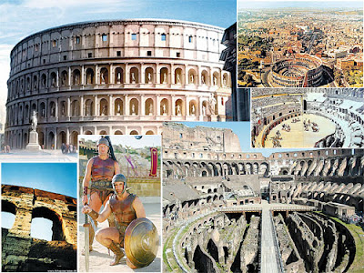
โคลอสเซียม สนามกีฬากรุงโรม อิตาลี

โคลอสเซียม สนามกีฬากรุงโรม อิตาลี
โคลอสเซียม (อังกฤษ: Colosseum หรือ Flavian Amphitheatre; อิตาลี: Colosseo - โคลอสโซ) เป็นสนามกีฬากลางแจ้งขนาดใหญ่ตั้งอยู่ใจกลางกรุงโรม เริ่มสร้างขึ้นในสมัยจักรพรรดิเวสเปเซียนแห่งจักรวรรดิโรมัน และสร้างเสร็จในสมัยของจักรพรรดิไททัส ในคริสต์ศตวรรษที่ 1 หรือประมาณปี ค.ศ. 80 อัฒจันทร์เป็น รูปวงกลมก่อด้วยอิฐและหินทรายวัดโดยรอบได้ประมาณ 527 เมตร สูง 57 เมตร สามารถจุผู้ชมได้ประมาณ 50,000 คน มีการออกแบบอย่างชาญฉลาดโดยสร้างให้สนามกีฬามีลักษณะเป็นรูปวงรี เพื่อให้ผู้ชมรู้สึกเข้าใกล้นักกีฬา และมีการออกแบบทางระบายน้ำเพื่อไม่ให้น้ำท่วมขังในสนามขณะเกิดฝนตก ถือเป็นต้นแบบของสนามกีฬาต่างๆในปัจจุบัน

ในบางครั้งจะมีการเรียกชื่อ โคลิเซียม (Coliseum)

7 กรกฎาคม พ.ศ. 2550 โคลอสเซียมได้รับเลือกให้เป็น1 ในเจ็ดสิ่งมหัศจรรย์ของโลกยุคใหม่ จากการลงคะแนนทั่วโลกทั้งทางอินเทอร์เน็ตและโทรศัพท์มือถือ

http://th.wikipedia.org/wiki/โคลอสเซียม


https://blogger.googleusercontent.com/img/b/R29vZ2xl/AVvXsEjIVd2UI0kvOA2Ci_TO7YuzlT3BECG58EnOUrZj1vTF8QjXX92OBc7fDjXSrbH2c9lg81TsjQ7BdmJqgTAxlggfSQPe0q26MzLyE0cDgYIiG8qMIoSVMaXZlZsW7XXooQhHitEUDJs_gPs/s400/artsmen-dot-net_data1561_83358335.jpg
http://europecastle.blogspot.com/2007/12/blog-post_17.html

Tuesday, February 22, 2011

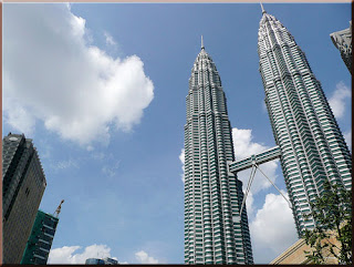
ตึกแฝด เปโตรนาส ทาวเวอร์ มาเลเซีย Petronas Twin Towers

ตึกแฝด เปโตรนาส ทาวเวอร์ มาเลเซีย Petronas Twin Towers

ตึกแฝดเปโตรนาส : Petronas Towers มหัศจรรย์สิ่งก่อสร้าง ...
เป โตรนาส (petronas twin tower) ตึกแฝดที่สูงที่สุดในโลก ที่สูงตระหง่านถึง 452 เมตร มีด้วยกัน 88 ชั้น ใช้งบประมาณการก่อสร้าง 20000 ล้านบาท ...
www.wonder7th.com/wonder_build/015petronas_towers.htm

อาคารหอคอยคู่เปโตรนาส (อังกฤษ: Petronas Twin Towers) เป็นสถาปัตยกรรมที่โดดเด่นของเมืองกัวลาลัมเปอร์ ประเทศมาเลเซีย ออกแบบโดย เซซาร์ เปลลี ตั้งอยู่บริเวณใจกลางย่านธุรกิจของเมือง ที่แวดล้อมด้วยสวนสาธารณะ และส่วนอาคารคอนเวนชั่นเซ็นเตอร์ (KLCC-Kuala Lumpur Convention Center) อาคารเปโตรนาส มี 2 อาคารหอคอย ซึ่งนับเป็นอาคารที่สูงอันดับ 3 และ 4 ของโลก รองจากอาคารเซี่ยงไฮ้เวิลด์ไฟแนนเชียลเซ็นเตอร์เมืองเซี่ยงไฮ้ และอาคารไทเป101 ประเทศไต้หวัน มีความสูงทั้งหมด452เมตร 88ชั้น

อาคารเปโตรนาสเป็นอาคารสำนักงาน ประกอบด้วยสำนักงานของบริษัทพลังงานและน้ำมันที่มีรัฐบาลมาเลเซียเป็นหุ้นหลักได้แก่ บริษัทเปโตรนาส (ปิโตรเลียมนาชันแนลเบอร์ฮาด) คือ บริษัท ปิโตรเลียมแห่งชาติ จำกัด ของมาเลเชีย ส่วนอื่นๆให้บริษัทอื่นๆเป็นผู้เช่า ได้แก่ บริษัททางการเงินและธนาคาร บริษัทผลิตภัณฑ์เคมีที่เกี่ยวข้องอื่นๆ ลักษณะเด่นเมื่อเปรียบเทียบกับตึกระฟ้า อื่นๆของโลก คือการที่เป็นอาคารหอคอย 2 อาคาร เชื่อมโดยสะพานลอยฟ้า (skybridge) อาคารแฝดใช้บริษัทรับเหมาก่อสร้างจาก 2 ประเทศ คือญี่ปุ่น และเกาหลี โดยมีนัยยะเป็นการแข่งขันกันเป็นผู้นำทางด้านเทคโนโลยีการก่อสร้างอาคารตึก ระฟ้า สะพานลอยฟ้านี้เคยใช้เป็นที่ถ่ายทำภาพยนตร์ฮอลีวูดมาแล้ว ปัจจุบันเปิดให้จองลงทะเบียนขึ้นไปชมวิวที่จุดนี้ (จำนวนจำกัด) โดยไม่เสียค่าใช้จ่าย เปิดอนุญาตให้ลงทะเบียนในช่วงเช้า เมื่อครบจำนวนจะหยุดให้ลงทะเบียนทันที

บริเวณฐานของอาคารมีห้างทันสมัยหลายห้าง เช่น อิเซตัน และนอกจากนี้ยังมีส่วนประกอบรอบๆเป็นอาคารคอนเวนชั่นเซ็นเตอร์ (ศูนย์ประชุม) สวนสาธารณะ สวนน้ำ สระน้ำพุดนตรี พิพิธภัณฑ์การเรียนรู้ (Discovery museum) และพิพิธภัณฑ์สัตว์น้ำอควาเรีย (Aquaria)

http://th.wikipedia.org/wiki/เปโตรนาสทาวเวอร์
http://images.thaiza.com/38/38_20081224150815..jpg
http://www.1000za.com/forum/viewthread.php?tid=35937

Wednesday, February 2, 2011

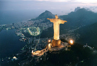
คริสโตรีเดนเตอร์ รูปปั้นของพระเยซู เมือง ริโอ เดอ จาเนโร บราซิล

คริสโตรีเดนเตอร์ รูปปั้นของพระเยซู เมือง ริโอ เดอ จาเนโร บราซิล
รูปปั้นของพระเยซู เมือง ริโอ เดอ จาเนโร : Statue Cristo Redentor ...
รูป ปั้นของพระเยซู เมือง ริโอ เดอ จาเนโร : Statue Cristo Redentor. สถานที่ตั้ง, เมือง Rio de Janeiro ประเทศบราซิล. ปัจจุบัน, สามารถเข้าเยี่ยมชมได้ ...
www.wonder7th.com/wonder_build/017statue_cristo_redentor.htm

รูปปั้นพระเยซูคริสต์ (โปรตุเกส: Cristo Redentor; อังกฤษ: Christ the Redeemer) ตั้งอยู่ที่ยอดเขากอร์โกวาดู ประเทศบราซิล มีความสูงราว 38 เมตร ได้รับการออกแบบโดยไฮตอร์ ดา ซิลวา กอสตา ชาวบราซิล และสร้างโดยพอล ลันดอฟสกี ประติมากรชาวฝรั่งเศสเชื้อสายโปแลนด์ ใช้เวลาในการสร้าง 5 ปี โดยทำพิธีเปิดอย่างเป็นทางการในวันที่ 12 ตุลาคม ปี พ.ศ. 2474

รูปปั้นพระเยซูคริสต์นี้ถือเป็นอนุสาวรีย์ที่มีชื่อเสียงมากที่สุดแห่งหนึ่งของโลก และได้กลายมาเป็นสัญลักษณ์ของนครรีโอเดจาเนโร และเป็นที่ยึดเหนี่ยวทางจิตใจของชาวบราซิล มีนักท่องเที่ยวเดินทางมายังสถานที่แห่งนี้ราว 1,800,000 รายต่อปี

http://th.wikipedia.org/wiki/คริสโตรีเดนเตอร์
http://www.rmutphysics.com/CHARUD/OLDNEWS/92/statue_cristo_redentor06.jpg
http://www.rmutphysics.com/CHARUD/OLDNEWS/92/index92.htm

Statue Cristo Redentor
รูปปั้นของพระเยซู เมือง ริโอ เดอ จาเนโร (Statue Cristo Redentor) ... รูปปั้นของพระเยซูที่โปรดให้พ้นบาป ยืนสูง 30 เมตร (98ฟุต) และกำลังมองข้ามเมือง Rio de ...
pirun.ku.ac.th/~b4910169/Statue%20Cristo%20Redentor.htm

Sunday, January 30, 2011

ยอดเขาเอเวอร์เรสต์ เทือกเขาหิมาลัย เนปาล

ยอดเขาเอเวอร์เรสต์ เทือกเขาหิมาลัย เนปาล
ยอดเขาเอเวอเรสต์ - วิกิพีเดีย
ยอดเขาเอเวอเรสต์ (Mount Everest) เป็นยอดเขาหนึ่งในเทือกเขาหิมาลัย ซึ่งเกิดจากการชนกันของแผ่นเปลือกโลกยูเรเซียนและแผ่นเปลือกโลกอินเดีย ในทางภูมิรัฐศาสตร์ ...
th.wikipedia.org/wiki/ยอดเขาเอเวอเรสต์

http://tce792.spaces.live.com/blog/cns!71FB750AFC8FC380!311.entry


ยอดเขาเอเวอร์เรสต์ เทือกเขาหิมาลัย เนปาล
ยอดเขาเอเวอเรสต์ (Mount Everest) เป็นยอดเขาหนึ่งในเทือกเขาหิมาลัย ซึ่งเกิดจากการชนกันของแผ่นเปลือกโลกยูเรเซียนและแผ่นเปลือกโลกอินเดีย ในทางภูมิรัฐศาสตร์ ยอดเขาเอเวอเรสต์ถือเป็นจุดแบ่งพรมแดนระหว่างประเทศเนปาลและทิเบต โดยชาวเนปาลเรียกยอดเขาเอเวอเรสต์ว่า สครมาถา (ภาษาสันสกฤต: सगरमाथा หมายถึง หน้าผากแห่งท้องฟ้า) ส่วนชาวทิเบตขนานนามยอดเขาแห่งนี้ว่า โชโมลังมา (จากภาษาจีน: 珠穆朗玛 [จูมู่หลั่งหม่า] หมายถึง มารดาแห่งสวรรค์)

ชื่อยอดเขาเอเวอเรสต์นั้น ตั้งโดย เซอร์แอนดรูว์ วอ นักสำรวจประเทศอินเดียชาวอังกฤษ เพื่อเป็นเกียรติแก่ เซอร์จอร์จ อีฟเรสต์ นักสำรวจประเทศอินเดียรุ่นก่อนหน้า (คำว่า Everest นี้ คนส่วนมากอ่านออกเสียงเป็น เอเวอเรสต์ ขณะที่เซอร์จอร์จอ่านออกเสียงชื่อสกุลของตัวเองว่า อีฟเรสต์) ซึ่งก่อนหน้านั้นนักสำรวจเรียกยอดเขาแห่งนี้เพียงว่า ยอดที่สิบห้า (Peak XV)


คนทั่วไปจดจำชื่อเอเวอเรสต์ได้ในฐานะยอดเขาที่สูงที่สุดในโลก แต่สำหรับชาวเชอร์ปา(Sherpa) และนักปีนเขา(climber) บางคนแล้ว ยอดเขาเอเวอเรสต์ไม่ได้เป็นเพียงแค่จุดที่สูงที่สุดบนพื้นโลกเท่านั้น หากยังเป็นจุดหมายสูงสุดในชีวิตพวกเขาด้วย การไปให้ถึงยอดเขาเอเวอเรสต์เป็นเรื่องที่ยากลำบาก แต่เมื่อยอดเขาเอเวอเรสต์ถูกพิชิตได้ นั่นหมายความว่าขีดจำกัดของมนุษยชาติได้เพิ่มขึ้นอีกขั้นหนึ่งแล้ว
http://th.wikipedia.org/wiki/ยอดเขาเอเวอเรสต์

Saturday, January 22, 2011

Petronas Twin Towers Malaysia

Petronas Twin Towers Malaysia Petronas Twin Towers Malaysia
Petronas Twin Towers - Wikipedia, the free encyclopedia
Below the twin towers is Suria KLCC, a shopping mall, and Dewan Filharmonik Petronas, the home of the Malaysian Philharmonic Orchestra. ...
en.wikipedia.org/wiki/Petronas_Twin_Towers

PETRONAS
Click the button below to install the plugin. click here to get the Flash-plug-in · Click here to Enter PETRONAS Corporate Website.
www.petronas.com.my/


Petronas Twin Towers Malaysia
http://greenstructures.wordpress.com/2009/08/12/top-five-tallest-buildings/

Petronas Twin Towers Malaysia

The Petronas Twin Towers (Malay: Menara Berkembar Petronas) (also known as the Petronas Towers or just Twin Towers), in Kuala Lumpur, Malaysia are twin towers and were the world's tallest buildings before being surpassed by Taipei 101. However, the towers are still the tallest twin buildings in the world. They were the world's tallest buildings from 1998 to 2004 if measured from the level of the main entrance to the structural top, the original height reference used by the international organization Council on Tall Buildings and Urban Habitat from 1969 (three additional height categories were introduced as the tower neared completion in 1996).

Comparison with other towers

In accordance to CTBUH, the pinnacles contributed to the overall height of the towers, thus surpassing the Willis Tower.

The Petronas Twin Towers were the tallest buildings in the world until Taipei 101 was completed in 2004, as measured to the top of their structural components (spires, but not antennas).Spires are considered integral parts of the architectural design of buildings, to which changes would substantially change the appearance and design of the building, whereas antennas may be added or removed without such consequences. The Petronas Twin Towers remain the tallest twin buildings in the world.

The Willis Tower and the World Trade Center towers were each constructed with 110 occupied floors – 22 more than the Petronas Twin Towers’ 88 floors. The Willis Tower and the World Trade Center’s roofs and highest occupied floors substantially exceeded the height of the roof and highest floors of the Petronas Twin Towers. The Willis Tower’s tallest antenna is 75 m (246 ft) taller than the Petronas Twin Towers’ spires. However, in accordance to CTBUH regulations and guidelines, the antennas of the Willis Tower were not counted as part of its architectural features. The spires on the Petronas Towers are included in the height since they are not antenna masts. Therefore, the Petronas Twin Towers exceed the official height of the Willis Tower by 10 m, but the Willis Tower has more floors and much higher square footage.

History

Designed by Argentine-American architect César Pelli, the Petronas Towers were completed in 1998 after a seven year build and became the tallest buildings in the world on the date of completion They were built on the site of Kuala Lumpur's race track.Because of the depth of the bedrock, the buildings were built on the world's deepest foundations. The 120-meter foundations were built within 12 months by Bachy Soletanche, and required massive amounts of concrete.

The 88-floor towers are constructed largely of reinforced concrete, with a steel and glass facade designed to resemble motifs found in Islamic art, a reflection of Malaysia's Muslim religion.[10] Another Islamic influence on the design is that the cross section of the towers is based on a Rub el Hizb (albeit with circular sectors added to meet office space requirements).

Due to a lack of steel and the huge cost of importing steel, the towers were constructed on a cheaper radical design of super high-strength reinforced concrete.[12] High-strength concrete is a material familiar to Asian contractors and twice as effective as steel in sway reduction; however, it makes the building twice as heavy on its foundation than a comparable steel building. Supported by 23-by-23 meter concrete cores[13] and an outer ring of widely spaced super columns, the towers use a sophisticated structural system that accommodates its slender profile and provides 560,000 square metres of column-free office space.[14] Below the twin towers is Suria KLCC, a shopping mall, and Dewan Filharmonik Petronas, the home of the Malaysian Philharmonic Orchestra.

Other buildings have used spires to increase their height but have always been taller overall to the pinnacle when trying to claim the title. In the aftermath of the controversy, the rules governing official titles were partially overhauled, and a number of buildings re-classified structural antenna as architectural details to boost their height rating (even though nothing was actually done to the building).

http://en.wikipedia.org/wiki/Petronas_Twin_Towers
http://architecture.desktopnexus.com/wallpaper/70087/

Tuesday, January 11, 2011

Stonehenge England

Stonehenge England

Stonehenge, England
Stonehenge, however, is roughly circular. It is difficult to precisely date the stone rings because of the scarcity of datable remains associated with them, ...
www.sacredsites.com/europe/england/stonehenge.html

Stonehenge England

Stonehenge is a prehistoric monument located in the English county of Wiltshire, about 3.2 kilometres (2.0 mi) west of Amesbury and 13 kilometres (8.1 mi) north of Salisbury. One of the most famous sites in the world, Stonehenge is composed of earthworks surrounding a circular setting of large standing stones. It is at the centre of the most dense complex of Neolithic and Bronze Age monuments in England, including several hundred burial mounds.[1] Archaeologists had believed that the iconic stone monument was erected around 2500 BC, as described in the chronology below. One recent theory, however, has suggested that the first stones were not erected until 2400-2200 BC, whilst another suggests that bluestones may have been erected at the site as early as 3000 BC (see phase 1 below). The surrounding circular earth bank and ditch, which constitute the earliest phase of the monument, have been dated to about 3100 BC. The site and its surroundings were added to the UNESCO's list of World Heritage Sites in 1986 in a co-listing with Avebury henge monument. It is a national legally protected Scheduled Ancient Monument. Stonehenge is owned by the Crown and managed by English Heritage, while the surrounding land is owned by the National Trust.

Archaeological evidence found by the Stonehenge Riverside Project in 2008 indicates that Stonehenge served as a burial ground from its earliest beginnings. The dating of cremated remains found on the site indicate burials from as early as 3000 BC, when the initial ditch and bank were first dug. Burials continued at Stonehenge for at least another 500 years.

http://en.wikipedia.org/wiki/Stonehenge

Stonehenge England
http://commons.wikimedia.org/wiki/File:Stonehenge_-_England.JPG

Wednesday, January 20, 2010

Dead Sea Israel Jordan

Dead Sea, Jordan
Dead Sea, Jordan. One of the most spectacular natural and spiritual landscapes in the whole world, the lowest point on earth, and the world's richest source ...
www.atlastours.net/jordan/deadsea.html

Dead Sea - Wikipedia, the free encyclopedia
Dead Sea at dawn (from Sodom mountain, Israel). Dead Sea at dusk (from Suwayma, Jordan). Sinkholes at Mineral Beach. Dead Sea from Masada ...
Etymology - Geography - Natural history - Climate
en.wikipedia.org/wiki/Dead_Sea

Dead Sea | Vote7
The Dead Sea is a salt lake between Palestine and Israel to the west and Jordan to the east. At 420 metres below sea level, its shores are the lowest point ...
www.vote7.com/n7w/nature/finalists/dead-sea

Dead Sea Israel Jordan
http://ianaloni.wordpress.com/2009/03/06/20-photos-of-israel/

Dead Sea Israel Jordan

The Dead Sea (Hebrew: יָם הַ‏‏מֶּ‏‏לַ‏ח‎, Yām Ha-Melaḥ, "Sea of Salt"; Arabic: البَحْر المَيّت‎, al-Baḥr El-Mayyit, "Dead Sea"), also called the Salt Sea, is a salt lake in Jordan to the east and in the West Bank and Israel to the west. Its surface and shores are 422 metres (1,385 ft) below sea level,[2] the lowest elevation on the Earth's surface on dry land. The Dead Sea is 378 m (1,240 ft) deep, the deepest hypersaline lake in the world. It is also one of the world's saltiest bodies of water, with 33.7% salinity. Only Lake Assal (Djibouti), Garabogazköl and some hypersaline lakes of the McMurdo Dry Valleys in Antarctica (such as Don Juan Pond and perhaps Lake Vanda) have a higher salinity. It is 8.6 times more salty than the ocean.[3] This salinity makes for a harsh environment where animals cannot flourish, hence its name. The Dead Sea is 67 kilometres (42 mi) long and 18 kilometres (11 mi) wide at its widest point. It lies in the Jordan Rift Valley, and its main tributary is the Jordan River.

The Dead Sea has attracted visitors from around the Mediterranean basin for thousands of years. Biblically, it was a place of refuge for King David. It was one of the world's first health resorts (for Herod the Great), and it has been the supplier of a wide variety of products, from balms for Egyptian mummification to potash for fertilizers. People also use the salt and the minerals from the Dead Sea to create cosmetics and herbal sachets.

The Dead Sea is an endorheic lake located in the Jordan Rift Valley, a geographic feature formed by the Dead Sea Transform (DST). This left lateral-moving transform fault lies along the tectonic plate boundary between the African Plate and the Arabian Plate. It runs between the East Anatolian Fault zone in Turkey and the northern end of the Red Sea Rift offshore of the southern tip of Sinai.

The Jordan River is the only major water source flowing into the Dead Sea, although there are small perennial springs under and around the Dead Sea, creating pools and quicksand pits along the edges.[6] There are no outlet streams.

Rainfall is scarcely 100 mm (3.9 in) per year in the northern part of the Dead Sea and barely 50 mm (2.0 in) in the southern part. The Dead Sea zone's aridity is due to the rainshadow effect of the Judean Hills. The highlands east of the Dead Sea receive more rainfall than the Dead Sea itself.

To the west of the Dead Sea, the Judean Hills rise less steeply, and are much lower, than the mountains to the east. Along the southwestern side of the lake is a 210 m (690 ft) tall halite formation called "Mount Sodom".

http://en.wikipedia.org/wiki/Dead_Sea

Wednesday, January 13, 2010

หอนาฬิกา บิ๊กเบน ลอนดอน อังกฤษ

http://upload.wikimedia.org/wikipedia/commons/thumb/e/e1/Clock_Tower_-_Palace_of_Westminster%2C_London_-_September_2006.jpg/200px-Clock_Tower_-_Palace_of_Westminster%2C_London_-_September_2006.jpg
http://th.wikipedia.org/wiki/บิ๊กเบน

บิ๊กเบน - วิกิพีเดีย
ข้ามไปยัง หอนาฬิกาที่ได้แรงบันดาลใจจากหอนาฬิกาพระราชวังเวสต์มินสเตอร์‎: หอ ...
โครงสร้างอาคาร - หน้าปัดนาฬิกา - ระฆัง "บิกเบน"
th.wikipedia.org/wiki/บิ๊กเบน

หอนาฬิกา บิ๊กเบน ลอนดอน อังกฤษ

หอนาฬิกาพระราชวังเวสต์มินสเตอร์ (Clock Tower, Palace of Westminster) หรือรู้จักดีในชื่อ บิ๊กเบน เป็นหอนาฬิกาประจำพระราชวังเวสต์มินสเตอร์ ซึ่งในปัจจุบันใช้เป็นรัฐสภาอังกฤษ ตั้งอยู่ทิศตะวันออกเฉียงเหนือของพระราชวัง หอนาฬิกานี้ถูกสร้างหลังจากไฟไหม้พระราชวังเวสต์มินสเตอร์เดิม เมื่อวันที่ 16 ตุลาคม พ.ศ. 2377 โดยชาลส์ แบร์รี เป็นผู้ออกแบบ หอนาฬิกามีความสูง 96.3 เมตร โดยที่ตัวนาฬิกาอยู่สูงจากพื้น 55 เมตร ตัวอาคารสร้างด้วยสถาปัตยกรรมสมัยสมเด็จพระราชินีนาถวิกตอเรีย (victorian gothic)

หลายคนเข้าใจว่าบิกเบนเป็นชื่อหอนาฬิกาประจำรัฐสภาอังกฤษ แต่แท้ที่จริงแล้ว บิกเบนเป็นชื่อเล่นของระฆังใบ ใหญ่ที่สุด หนักถึง 13,760 กิโลกรัม ซึ่งแขวนไว้บริเวณช่องลมเหนือหน้าปัดนาฬิกา ทั้งนี้มีระฆังรวมทั้งสิ้น 5 ใบ โดย 4 ใบจะถูกตีเป็นทำนอง ส่วนบิกเบนจะถูกตีบอกชั่วโมงตามตัวเลขที่เข็มสั้นชี้บนหน้าปัดนาฬิกา ทว่าคนส่วนใหญ่กลับใช้ชื่อบิกเบนเรียกตัวหอทั้งหมด

บางทีมักเรียกหอนาฬิกานี้ว่า หอเซนต์สตีเฟน (St. Stephen's Tower) หรือหอแห่งบิกเบน (Tower of Big Ben) ซึ่งที่จริงแล้วชื่อหอเซนต์สตีเฟนคือชื่อของหอในพระราชวังอีกหอหนึ่ง[1] ซึ่งใช้เป็นทางเข้าไปอภิปรายในสภา ปัจจุบันภายในหอนาฬิกาไม่เปิดให้สาธารณชนเข้าชม เว้นแต่สำหรับผู้ที่อาศัยในประเทศอังกฤษ จะต้องทำเรื่องขอเข้าชมผ่านสมาชิกรัฐสภาอังกฤษประจำท้องถิ่นของตน ถ้าเป็นเด็กต้องมีอายุเกิน 11 ปี จึงจะเข้าชมหอได้ สำหรับชาวต่างประเทศนั้นยังไม่อนุญาตให้ขึ้นไป

http://th.wikipedia.org/wiki/บิ๊กเบน

แผนที่ : (กด + ซูมเข้า , กด - ซูมออก , กด ลูกศร ขึ้น ลง ซ้าย ขวา)

Friday, January 8, 2010

อุโมงค์ แชลแนล เทิลแนว อังกฤษ ฝรั่งเศส

ติดต่อคมนาคมระหว่างอังกฤษกับฝรั่งเศส

เป็นอุโมงค์ที่ให้ลอดใต้ช่องแคบอังกฤษ Channel Tunnel เป็นอุโมงค์ลอดใต้ทะเล ที่ยาวที่สุดในโลก คือมีความยาวถึง 49.94 กิโลเมตร อุโมงค์นี้มีทั้งทางวิ่งของรถไฟและรถยนต์ ทำให้การติดต่อคมนาคมระหว่างอังกฤษกับฝรั่งเศสเป็นไปอย่างสะดวกมาก

http://i26.tinypic.com/sbrq4z.jpg
http://archloader.blogspot.com/2009/05/national-geographic-megastructures_5513.html

อุโมงค์ แชลแนล เทิลแนว อังกฤษ ฝรั่งเศส

รถไฟที่ใช้วิ่งในอุโมค์นี้ ก็เป็นรถไฟด่วนแบบเดียวกับ รถไฟด่วน TGV (รถไฟที่เร็วที่สุดในโลก ของฝรั่งเศส) มีชื่อว่า ยูโรสตาร์ วิ่งที่ความเร็วเกือบ 280 กิโลเมตรต่อชั่วโมง เมื่ออยู่บนแผ่นดินฝรั่งเศส แต่เมื่อช่วงลอดอุโมงค์และวิ่ง ในอังกฤษจะลดความเร็วลงไปอีกมากด้วยเหตุผลทางด้านกฎเกณฑ์ของอังกฤษ

http://www.wonder7th.com/wonder_build/022channel_tunnel.htm

แผนที่ :

Channel Tunnel England France

The Channel Tunnel (French: Le tunnel sous la Manche), known colloquially as the Chunnel, is a 50.5-kilometre (31.4 mi) undersea rail tunnel linking Folkestone, Kent near Dover in the United Kingdom with Coquelles, Pas-de-Calais near Calais in northern France beneath the English Channel at the Strait of Dover. At its lowest point it is 75 metres (250 ft) deep. At 37.9 kilometres (23.5 mi), the Channel Tunnel has the longest undersea portion of any tunnel in the world although the Seikan Tunnel in Japan is both longer overall, at 53.85 kilometres (33.46 mi) and deeper, at 240 metres (790 ft) below sea level.

The tunnel carries high-speed Eurostar passenger trains, Eurotunnel Shuttle roll-on/roll-off vehicle transport—the largest in the world—and international rail freight trains.[4] The tunnel connects end-to-end with the LGV Nord and Channel Tunnel Rail Link high-speed railway lines. In 1996 the American Society of Civil Engineers identified the tunnel as one of the Seven Wonders of the Modern World.

http://img.dailymail.co.uk/i/pix/2007/08_01/speed030807R_468x333.jpg
http://www.dailymail.co.uk/news/article-505896/Illegal-immigrants-walk-miles-Channel-Tunnel-attempt-sneak-UK.html

Ideas for a cross-Channel fixed link appeared as early as 1802, but British political and press pressure over compromised national security stalled attempts to construct a tunnel. However, the eventual successful project, organised by Eurotunnel, began construction in 1988 and opened in 1994. The project came in 80% over its predicted budget. Since its construction, the tunnel has faced several problems. Fires have disrupted operation of the tunnel. Illegal immigrants and asylum seekers have used the tunnel to enter Britain, causing a minor diplomatic disagreement over the siting of the Sangatte refugee camp, which was eventually closed in 2002.

http://en.wikipedia.org/wiki/Channel_Tunnel

Map :